| Aerial Photography James S. and Susan W. Aber |
|
| Aerial Photography James S. and Susan W. Aber |
| Altitude (feet) | Pressure (in. Hg) | Temp. (F°) | Density (%) |
|---|---|---|---|
| sealevel | 29.92 | 59.0 | 100 |
| 2,000 | 27.82 | 51.9 | 94.3 |
| 4,000 | 25.84 | 44.7 | 88.8 |
| 6,000 | 23.98 | 37.6 | 83.6 |
| 8,000 | 22.22 | 30.5 | 78.6 |
| 10,000 | 20.57 | 23.3 | 73.8 |
| 12,000 | 19.02 | 16.2 | 69.3 |
| 14,000 | 17.57 | 9.1 | 65.0 |
| 16,000 | 16.21 | 1.9 | 60.9 |
The relationship of pressure, temperature, and humidity can be understood in terms of the density altitude, which is the equivalent "standard altitude" based on actual conditions at a site. Take the following example, in which pressure is 20½ inches of mercury (std. at 10,000 feet), humidity is 50%, and temperature is 60°F. The density altitude is equivalent to about 12,500 feet in the standard atmosphere, which is less than 70% of sealevel air density. To achieve sufficient lift, a very large kite or train of kites would be necessary to hold up the KAP rig.
| Mountain KAP |
High-altitude kite flying usually means mountains. Mountain ranges often create strong local weather effects, which include enhanced cloud cover and more precipitation than for adjacent lowlands. Mountain peaks and valleys are well known for rapid weather changes. Swirling winds funnel along valleys and over passes with frequent and abrupt changes in direction. Finding a large enough space for kite flying can be a challenge in forested mountains, and access to alpine areas above timberline can be quite limited. Areas with good access are often sites with other human structures and activities that could prove dangerous for kite flying. Highways, buildings and power lines follow the valleys. Towers, ski lifts and cable cars may occupy the higher slopes and mountain peaks. The combination of cloud cover, fickle wind, and limited access makes for difficult kite aerial photography in many mountain settings.
The following kite aerial photographs were taken in vicinity of Cuchara, Colorado in June 1999. The single-camera, radio-controlled KAP rig was utilized with Kodak Elite 200 color-slide film. All photographs © J.S. Aber.
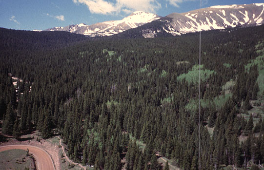
| View over Blue Lakes campground with Trinchera Peak (13,517 feet) in the center background. Dark trees are mainly blue spruce and lighter trees are aspen. Ground elevation of kite flyers about 10,400 feet. Flying the KAP rig in this narrow valley proved to be quite tricky. |
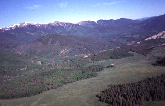
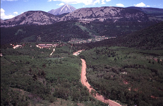
| View toward the Culebra Range from Cucharas Pass. Blue/Bear Lakes campground is located at extreme left edge of view (up the red-colored valley), and Cuchara Mountain Resort is in the right background. Ground elevation of kite flyers about 10,000 feet. |
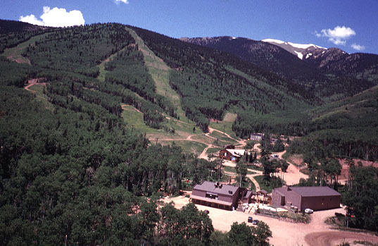
| Cuchara Mountain Resort base area and ski runs. The crest of the Culebra Range can be seen in the right background. Ground elevation of kite flyers about 9200 feet. Large parking area for the ski resort was a good site for flying the KAP rig. |
| View eastward from Cuchara Mountain Resort. The top of West Spanish Peak (13,626 feet) is visible on the far horizon. The light-colored, rocky ridge in front of West Spanish Peak is granite outcrop of White Peaks. Ground elevation of kite flyers about 9200 feet. |