Field Geology 2009: |
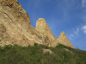
One rock wall of the impressive swarm of dikes that surround Spanish and Silver Peaks west of Walsenberg, Colorado. Photo by J.S. Aber; Photo date May 2006. |
Field Geology 2009: |
One rock wall of the impressive swarm of dikes that surround Spanish and Silver Peaks west of Walsenberg, Colorado. Photo by J.S. Aber; Photo date May 2006. |
As we move our field geology course west, you can look at Colorado from a Kansas perspective! After leaving Kansas, we will drive through La Junta. At that point, we leave the ribbon of darker blue color, the Arkansas River Valley, and continue driving into the "cyan prairie," arriving left of Pueblo at the first mountain range. We will then navigate in the colored areas of green, yellow, brown, and white in south-central Colorado! As we are driving, you can be reading a suggested course textbook, Messages in Stone (dnr.state.co.us/geostore/ProductInfo.aspx?productid=SP-52).
| Physiographic Provinces | Elevation and Geology Maps | Maps of Specific Geologic Time Periods |
| Geologic Time Chart | Geology Map Mashup | References and Links |
| What about identifying rocks in my collection? Go to www.geospectra.net/fieldgeology/rocks.htm | ||
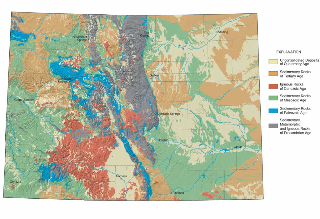
 Map taken from the Colorado Geological Survey geosurvey.state.co.us/Default.aspx?tabid=131 |
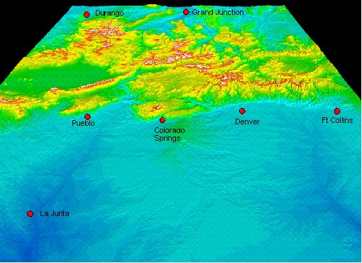
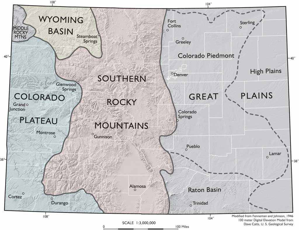
Spanish Peaks and Tinchera Peak are points of interest for field geology and are situated in the physiographic provinces of Raton Basin and Southern Rocky Mountains in south-central Colorado. Physiographic provinces categorize Colorado by overall landscape, vegetation, and physical geology. In these two provinces, elevations range from over 3,000 to over 14,000 feet; vegetation ranges from cholla cactus (Opuntia) to Colorado blue spruce (Picea pungens). The Raton Basin is a relatively flat plain that ramps up to the west and is distinguished by major igneous intrusive features such as East and West Spanish Peaks near La Veta. The Southern Rocky Mountains physiographic province varies greatly from steep, massive mountains such as Trinchera Peak near Cuchara to the large, high desert of the San Luis Valley where Alamosa is situated centrally.
A dramatic change in the landscape is highlighted in the shaded relief map below. The eastern two-fifths of the state is a relatively uninterrupted plain, while an abrupt change in elevation is obvious to the central and western parts of the state. Spanish Peaks rises 7,000 feet above the western Great Plains and are located at the extreme west edge of the Raton Basin province. It is easy to understand that one of the major rivers in Kansas has its headwaters near Leadville, over 10,000 feet in elevation; the Arkansas River exits Kansas at an elevation of just over 1,000 feet, on its way to the Mississippi River and Gulf of Mexico. According to Kammerer (1990), the Arkansas river is the sixth longest river in the United States, at 1,469 miles (pubs.usgs.gov/of/1987/ofr87-242/). |
|
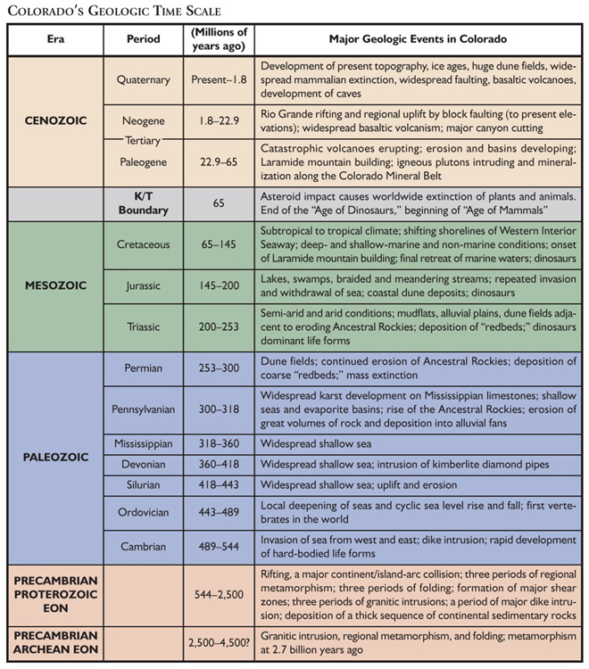
Although seven physiographic provinces are defined in Colorado, there are basically three topographic/geologic zones in the state. Topographically, the state is divided into Eastern Plains, Rocky Mountains, and Colorado Plateau. Geologically, the eastern plains and western plateau are composed of sedimentary rock whereas, the Rocky Mountain province is a complex assortment of igneous, metamorphic, and sedimentary rocks in approximate equal proportions (waterknowledge.colostate.edu/geology.htm).
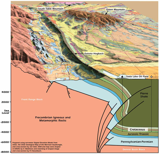
The Raton Basin is known for the exposed rocks defining the Cretaceous-Tertiary boundary. The Raton Basin transitions into the Southern Rocky Mountains when we cross the Cretaceous Dakota Sandstone hogback into the Lower Permian. This is roughly the same age of rock we left over 500 miles behind in Chase County, Kansas (www.geospectra.net/fieldgeology/kansasrocks.htm).
|
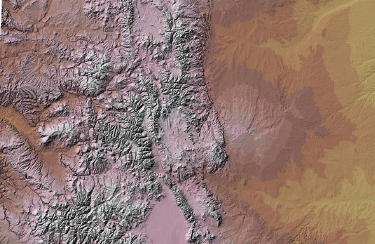
This shaded relief map was taken from geosurvey.state.co.us/Default.aspx?tabid=129. For more information, see geosurvey.state.co.us/pubs/shaded_relief/color_hs.pdf">
|

Distribution of Wind Deposited Quaternary Rocks. Image taken from geosurvey.state.co.us/ Default.aspx?tabid=425 | 
Distribution of Quaternary Rocks. Image taken from geosurvey.state.co.us/Default.aspx?tabid=424 |
Distribution of Late Neogene and Quaternary Basalt Flows. Image taken from geosurvey.state.co.us/ Default.aspx?tabid=415 | 
Distribution of Tertiary Volcanics. Image taken from geosurvey.state.co.us/Default.aspx?tabid=445 |

Distribution of Tertiary Rocks. Image taken from geosurvey.state.co.us/Default.aspx?tabid=422 | 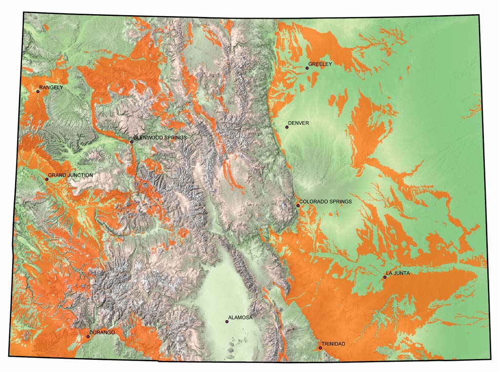
Distribution of Cretaceous Rocks. Image taken from geosurvey.state.co.us/Default.aspx?tabid=417 |

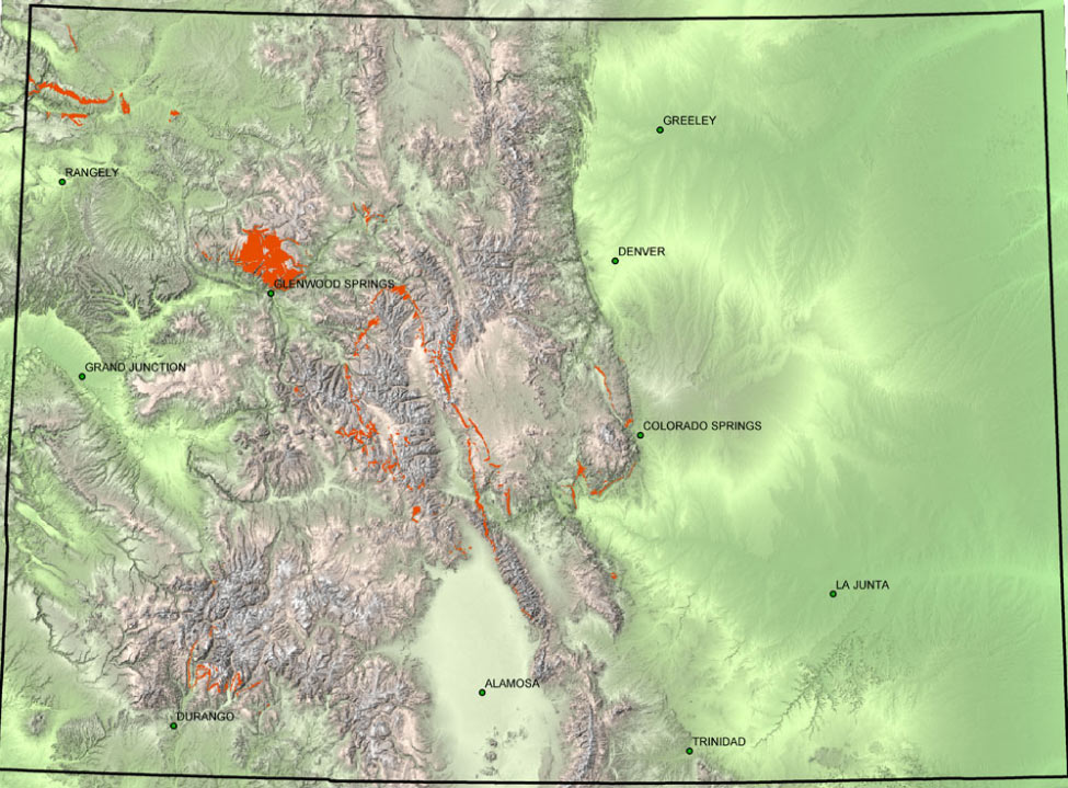
Distribution of Triassic and Jurassic Rocks. Image taken from geosurvey.state.co.us/ Default.aspx?tabid=415 | 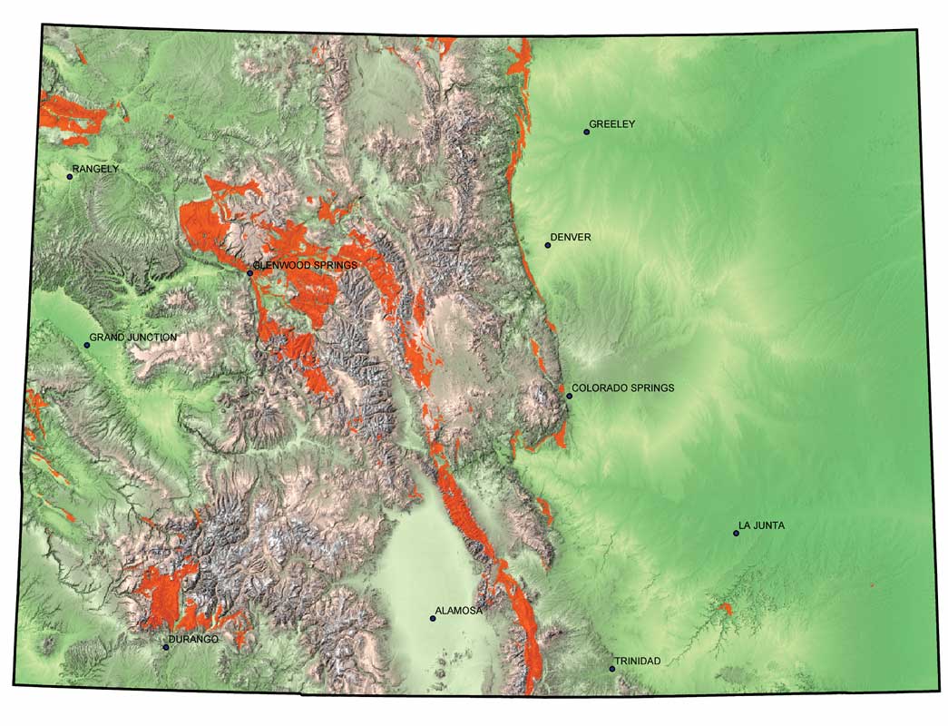
Distribution of Pennsylvanian and Permian Rocks. Image taken from geosurvey.state.co.us/ Default.aspx?tabid=415 |
Distribution of Lower and Middle Paleozoic Rocks. Image taken from geosurvey.state.co.us/ Default.aspx?tabid=428 | 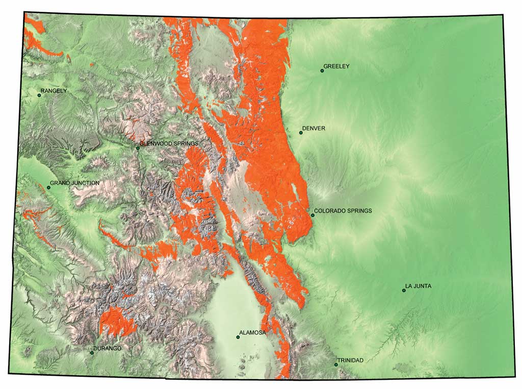
Distribution of Precambrian Rocks. Image taken from geosurvey.state.co.us/Default.aspx?tabid=290 |
This webpage provides ideas for information that may fit into the theme of your final report or merely make a topic clear. Links are given below for additional Colorado materials. Do not forget to cite and reference throughout your report. If you have any questions about good writing to avoid plagiarism, obtain the following resource:
This page is associated with Earth Science
and is primarily for the use and benefit of students enrolled at Emporia State University. For more information contact the course instructor, S. W. Aber, e-mail: saber@emporia.edu Thanks for visiting! Last update: 6 June, 2009. copyright 2009 © Susan Ward Aber. All rights reserved.
Harris, R. A. (2005). Using sources effectively strengthening your writing and avoiding plagiarism (2nd ed). Los Angeles, CA: Pyrczak Publishing (www.virtualsalt.com/usead.htm).
Reference and Weblinks of Interest
Kammerer, J.C. (2005). Largest rivers in the United States. U.S. Geological Survey, Department of the Interior, Water Fact Sheet, Open-File Report 87-242. Online at pubs.usgs.gov/of/1987/ofr87-242/. Retrieved June 6, 2009.
 Return to Exploring the Flint Hills of Kansas, http://www.geospectra.net/fieldgeology/fieldgeology.htm, or GO547 Field Geology course webpage, academic.emporia.edu/aberjame/field/geology.htm.