James S. Aber
|
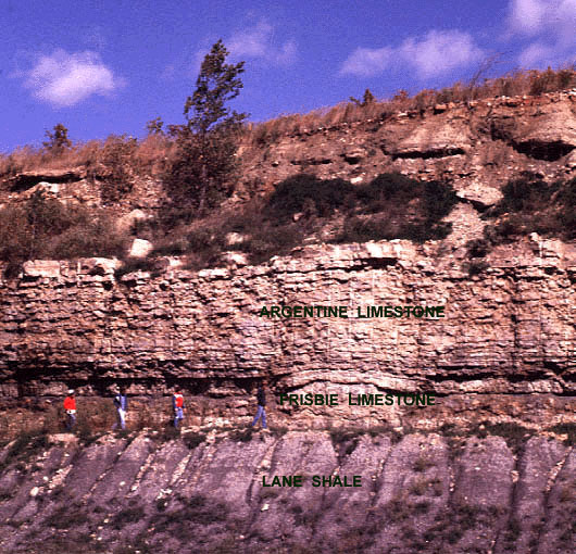
| Exposure of bedrock at the Holliday interchange of I-435, Kansas City, Kansas. The Argentine Limestone is widely quarried for building materials in Wyandotte and Johnson counties, Kansas. The normally thin Frisbie Limestone here includes a small mound (see next photo). The limestones and underlying Lane Shale contain a great variety of invertebrate fossils. Photo date 10/85, © J.S. Aber. |
|
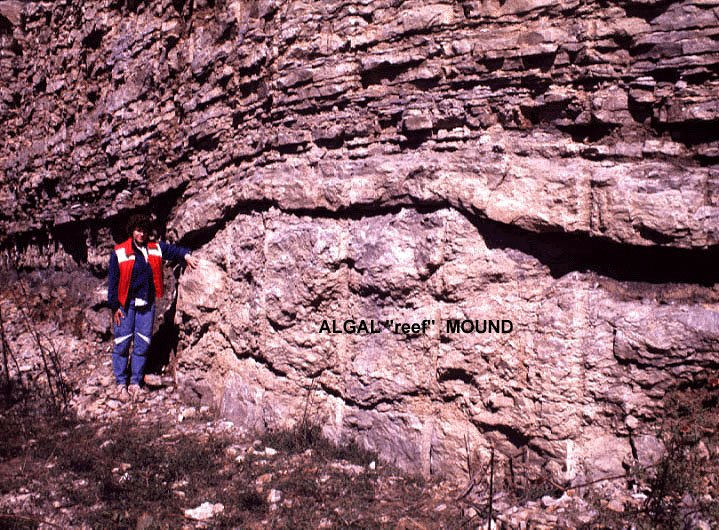
| Jackie Puterbaugh demonstrates a small "reef" in the Frisbie Limestone at Holliday, Kansas. The reef is a mound constructed of phylloid algae, which lived on a shallow sea floor, probably less than 25 feet (8 m) deep (Crowley 1969). Photo date 10/85, © J.S. Aber. |
While the Kansas City region was relatively stable during the late Pennsylvanian, great tectonic events took place to the east, south, and west. The Appalachian and Ouachita mountain systems were thrust up as North America collided with a vast southern continent named Gondwana, which included modern Africa, South America, India, Australia and Antarctica. The result of these collisions was creation of a supercontinent named Pangaea, meaning all lands, which encompassed all modern continents. Meanwhile to the west, the Ancestral Rocky Mountains were uplifted in Colorado adjacent to a convergent plate boundary on the margin of the continent.
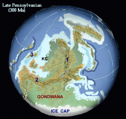
| Continental reconstruction of Pangaea for the late Pennsylvanian Period. KC = approximate location of Kansas City vicinity, 1 = Appalachian Mountains, 2 = Ouachita Mountains, 3 = Ancestral Rocky Mountains. Continental glaciation took place in the south polar Gondwana region, while a shallow tropical sea covered what is now the midcontinent of North America. Adapted from (Blakey 1997; used by permission). |
Pangaea was an enormous landmass that stretched from the South Pole, across the equator, to high northern latitudes. The south polar region of Gondwana was subjected to ice-sheet glaciation. Growth and decay of ice sheets led to frequent fluctuations of global sea level. The result in the Kansas City region was repeated marine transgressions and regressions. As sea level rose and fell, the shoreline migrated back and forth across the midcontinent area. Sequences of limestone, shale, and sandstone strata are a reflection of the alternating marine and terrestrial environments during the late Pennsylvanian Period. Repeated sequences of sedimentary rocks are called cyclothems, and the upper Pennsylvanian strata of the Kansas City region are world-famous examples of cyclothems (Moore 1930, 1964; Boardmand and Barrick 1989).
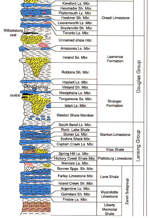
| Detailed stratigraphic chart for upper Pennsylvanian strata. These strata are found mainly in Johnson, Wyandotte, and Leavenworth counties of northeastern Kansas. The chart continues below with lower strata. Click on the small image to see a full-sized version (154 kb). Obtained from the Kansas Geological Survey (1997). |
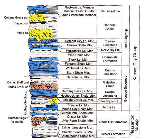
| Detailed stratigraphic chart for upper Pennsylvanian strata. These strata are found mainly in the Kansas City, Missouri area. The chart continues above with higher strata. Click on the small image to see a full-sized version (129 kb). Obtained from the Kansas Geological Survey (1997). |
The basic upper Pennsylvanian cyclothem consists of two portions--lower terrestrial section and upper marine section (Laporte and Imbrie 1964). Although the individual strata may seem complicated, the overall patterns are quite consistent and may be identified in many cyclothems of the region.

| Section in the Oread Limestone at Atchison, Kansas. Two shale and two limestone members are exposed. The Plattsmouth, Heebner, and Leavenworth make up the fundamental marine triad of this classic upper Pennsylvanian cyclothem. Photo date 6/85, © J.S. Aber. |
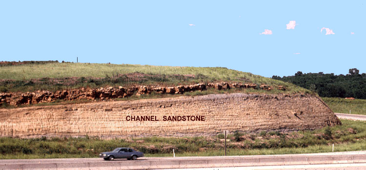
| Channel sandstone exposed in the I-70 and I-435 interchange, Kansas City, Kansas. Such sandstone bodies represent delta and/or river channels in a low-lying coastal environment during the late Pennsylvanian. Plant fragments and petrified wood are found in sandstone. Photo date 7/90, © J.S. Aber. |
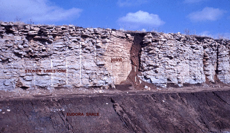
| Large joint in the Stoner Limestone near Eudora, Kansas. The original joint (fracture) was enlarged by groundwater solution and later infilled with glacial sediment and soil. Scale pole marked in feet. Photo date 1/77, © J.S. Aber. |
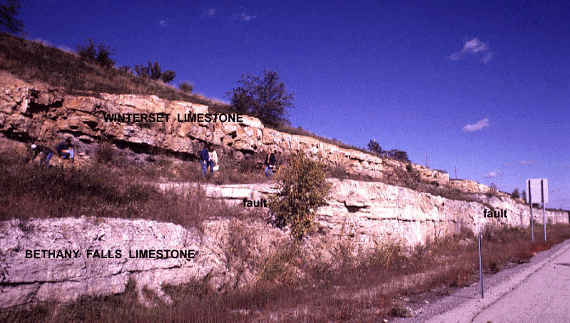
Fractures that display rock displacement are called faults. A few small faults are known in the region, for example near Raytown, Missouri, where the Bethany Falls and Winterset limestones are offset by a series of small normal faults. The faults are interpreted as the result of collapse of surficial rock into caverns formed by groundwater solution in the underlying Mississippian limestone and dolostone beds some 600-800 feet below the present land surface (Gentile 1984). Unconsolidated Pleistocene sediments above the bedrock are not affected by fault movement, which indicates the faults are not active in modern times.
| Two faults displayed in a section on I-470 at Raytown Road, Missouri. The faults appear as small steps in the bedrock surfaces. The Bethany Falls Limestone is exploited in mines and quarries, especially along the eastern side of Kansas City, Missouri. Photo date 10/85, © J.S. Aber. |
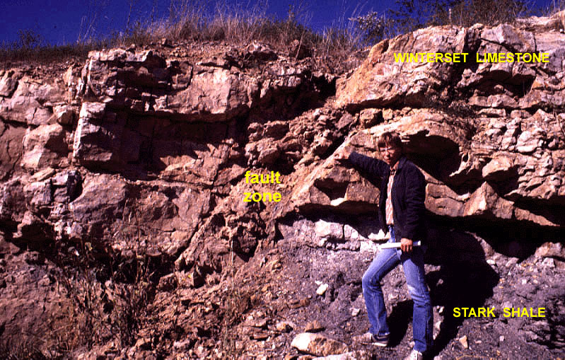
| Brad Hedstrom demonstrates a small normal fault in the Winterset Limestone, Raytown, Missouri. The "fault zone" contains broken and crushed rock fragments resulting from movement of the bedrock blocks on either side. Photo date 10/85, © J.S. Aber. |
Rivers and streams of eastern Kansas and western Missouri display distinct asymmetry in their development, which is most apparent for river valleys oriented east-west. The rivers flow predominately along the southern sides of the valleys--regardless of whether the river flows toward the east or west. For example, the Kansas River flows along the southern side of its valley for nearly its entire length. During the past few million years, rivers have gradually migrated southward as they eroded downward into bedrock valleys. The result is steep bedrock bluffs along the southern sides of valleys, whereas the northern sides often have gentle slopes with old river gravel deposits preserved on terraces. The old river gravels date from the late Tertiary Period, 1½ to 10 million years ago. This asymmetric pattern of valley erosion is the result of long-term, subtle crustal tilting down to the south (Aber 1992). The midcontinent crust is presumably sinking very slowly toward the Gulf Coast region of Texas and Louisiana.
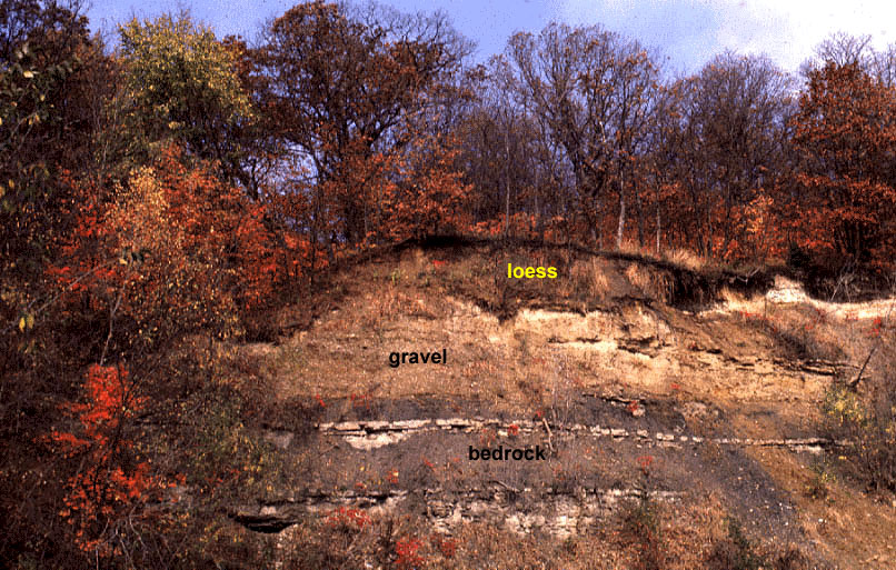
| Tertiary gravel preserved on a bedrock bench on the northwestern side of the Missouri River valley, north of Atchison, Kansas. The gravel consists mainly of chert (flint) derived from the Flint Hills as well as far-travelled exotic pebbles (see next photo). This gravel predates glaciation of the region; the loess is wind-blown dust that postdates glaciation. Photo date 10/89, © J.S. Aber. |
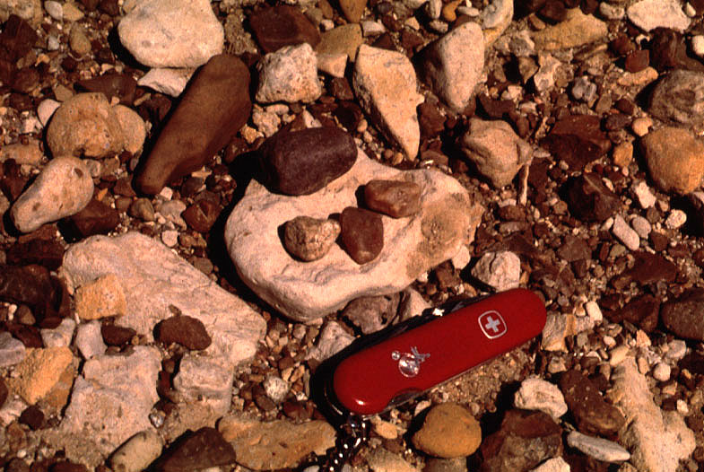
| Closeup view of Tertiary gravel below glacial deposits at Wathena, Kansas. Most of the gravel is chert (flint) derived from the Flint Hills. Small pebbles at center are quartzite exotics carried by streams from the High Plains and Rocky Mountains. Photo date 9/89, © J.S. Aber. |
Return to Kansas City geology homepage.
Last update Feb. 2005; © J.S. Aber.