| James S. Aber |
| Glacial sediment | Glacial till |
| Depositional landforms | Drumlins |
| Related sites | References |
|
| James S. Aber |
| Glacial sediment | Glacial till |
| Depositional landforms | Drumlins |
| Related sites | References |
Glacial sediment can be divided in two general categories: till and stratified sediment. Till is defined as "... a sediment that has been transported and is subsequently deposited by or from glacier ice, with little or no sorting by water" (Dreimanis and Lundqvist 1984, p. 9). It is material that was released from glacier ice usually by melting and was deposited without significant transportation or sorting due to water or gravity movements.
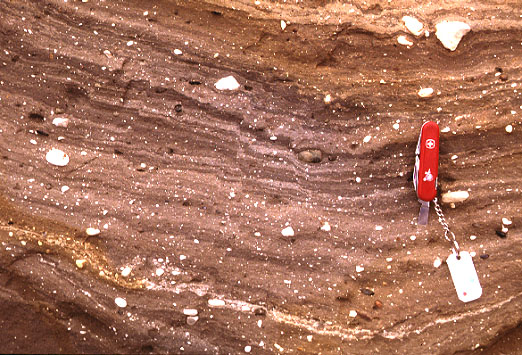
| First Cromer till at West Runton, United Kingdom. Strongly banded (sheared) till with pebbles of white chalk and black flint. Small secondary faults are present. Red pocket knife for scale. Photo © by J.S. Aber. |
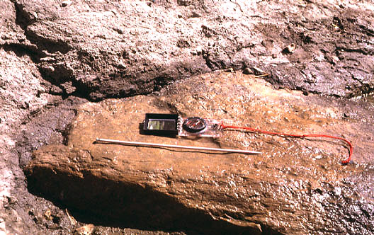
| Stratified sand and gravel deposited by glacial melt water in south-central New York. Note variable bedding, sorting, and grain size of sediment. Scale pole marked in feet. Photo © by J.S. Aber. |
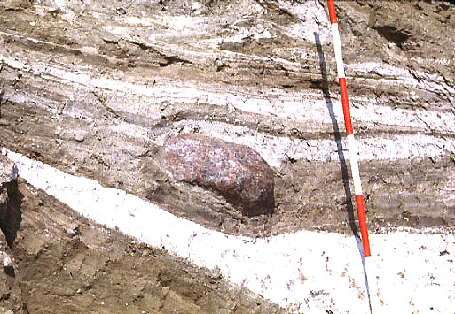
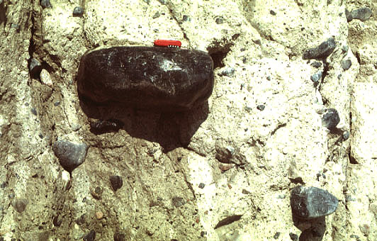
| Chalk-banded glacial mélange on the island of Møn, southern Denmark. Chalk, till, and sand are sheared and folded around the granite cobble. Ice movement from right to left; scale pole marked in 20-cm intervals. Photo © J.S. Aber. |
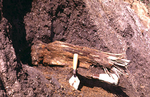
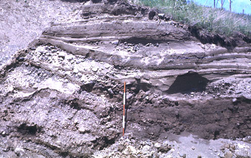
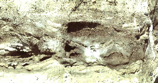
| Lower gray till exposed at Cedar Bluffs, eastern Nebraska. Note fragment of spruce wood preserved in till. The ice advance that deposited the till apparently overran the remains of a boreal spruce forest. Photo © by J.S. Aber. |
| Oriented boulder embedded in lower gray till at Atchison, Kansas. Striations on the boulder top trend N60E, parallel to the boulder's long axis. Such features indicate the direction of ice movement (NE to SW) at the time of till deposition. Needle is 14 inches (35 cm) long. Photo © by J.S. Aber. |
Ground moraine is deposited as a nearly flat plain beneath an ice
sheet; whereas various types of moraine ridges or hills build up in
ice-margin positions. The latter category includes: end, lateral,
interlobate, ribbed, and hummocky moraine. These moraines and other glacial
landforms are nicely illustrated on the Glacial Map of Canada
(Prest et al. 1967).
Depositional landforms
Landforms of glacial deposition are many and varied, including several
kinds of moraines. This term is a French word that originally
referred to rubbly piles of debris in front of alpine glaciers. It is now
used in many different contexts referring to constructional landforms
(American) or deposits (European). Moraines may be composed of diamicton
and/or stratified sediment.
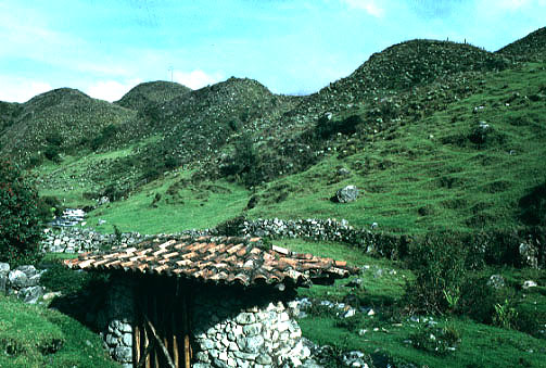
Massive end moraine of Late Mérida (Wisconsin) age, located behind the Los
Frailes hotel in the Venezuelan Andes Mountains. This moraine was deposited by
a large valley glacier that advanced from the left.
Photo © by J.S. Aber.
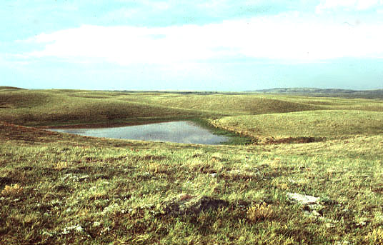
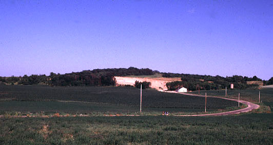
Hummocky moraine landscape in southwestern Saskatchewan, Canada. The
hummocky topography resulted when ice stagnated in the "Gap" between the
western and central blocks of the Cypress Hills (high plateau on horizon
to right). Irregular deposits and hollows formed as the ice wasted away.
Photo © by J.S. Aber.
Hummocky moraine with many small lake basins at Kurtkowiec, Tatra Mountains,
southern Poland. Small recessional and medial moraines form dams for lake
basins of irregular size and shape. View in the downglacier direction.
Photo © by J.S. Aber. Drumlins
Drumlins are among the most distinctive glacial
landforms. Drumlins are streamlined hills ideally having the shape of a
teardrop or inverted spoon. They occur in fields
containing dozens or hundreds to thousands of individual drumlins. They
are arranged en echelon in broad belts or arcs behind conspicuous
ice-margin positions, and the pattern of drumlins is thought to indicate
ice flow directions.
Aerial view of classic drumlins in east-central Wisconsin. Elongated,
streamlined hills with blunt upice ends. Ice movement from left to right.
© JLM Visuals (134/07).
Cross section through core of large drumlin at Galway, western Ireland. Drumlin
consists of crudely layered till with pockets of stratified sediments. Ice movement was from
left to right. Section is about 10 m high. Photo © by J.S. Aber.
Closeup view of "boulder-clay" till within drumlin at Galway. Smooth dark stones
are Paleozoic limestone. Red pocket knife for scale. Photo © by J.S. Aber.
Closeup view of stratified layer within drumlin at Galway. The sand and gravel were
deposited by subglacial meltwater and then slightly deformed—note small faults in lower
part of view. Photo © by J.S. Aber.
Typical drumlin in east-central Wisconsin. This overview shows asymmetrical longitudinal
profile of drumlin form. Ice movement is left to right. Photo © by J.S. Aber.

Internal structure of drumlin in east-central Wisconsin (see above). Note the large
overturned fold with red-brown till (right) wrapped around core of deformed
sand. Ice movement is left to right. Photo © by J.S. Aber.  Related sites

 Glossary or
references.
Glossary or
references.
Return to Glacial geomorphology (2020).
All images and text © J.S. Aber.
 Table of Contents